Let me tell you a story...

This little blog is about me, Hailey and my pursuit of happiness. I've decided to move on from modeling and to a new chapter of my life, artisry. I paint, I take pictures and I enjoy junking for vintage goods. All of this is done with lots of day dreaming in between.

I have a shop on Etsy that I just opened up in Feb 2009 and I am excited to see where it goes from there.

Thank you for your love and support.

Hailey
Showing posts with label road trip. Show all posts

Monday, October 26, 2009

Cassiar Highway Canada

The Cassiar Highway runs from the Yellowhead Highway (just west of Watson Lake which is where the sign forest is, remember the pictures on our way up?) to Kitwanga Canada where it ties back into the Alaska Highway.  According to the map, this stretch of road is 450 miles.  It felt like a forgotten road.

The speed limit signs said we could go about 50 mph so that's what I attempted to do.  Darren was sleeping but quickly woke up when I about drove us off the road.  It was really dark and the road twisted and turned with no warning.  So I slowed it down.

Just as Darren was falling asleep again I came to a screeching halt.. I could see large shadows right along the side of the road.  First I thought it was a bear but then with a closer look we discovered it was two buffalo bedded down on the shoulder of the road.  Darren thought this was cool.  He rolled down his window and stuck his head out to get a closer look.  We were maybe 8 feet away from the beasts.  Within a few seconds though, one buffalo decided we were a bit too close and rose to his feet.  His head was almost to the top of our truck and by now he was about 6 feet away.  You could almost reach out and pet him.  I suddenly got a cold chill down my spine and common sense kicked in.. "This beast of a buffalo ... should he decide he didn't like Darren hanging out the window pointing at him, ram into the side of my truck... he'd be in the cab with us, we'd be injured, the truck would probably be a mess and unable to drive much further...  Hell No!"  I put that truck into "drive" and pulled away.  It was amazing to be that close to the beasts, a moment we will never forget.


I drove down the dark, winding, ill repaired road for a couple hours and was getting sleepy.  I found a good wide spot to pull over.  We hadn't passed a single vehicle.  It really felt like we were all alone out here.  Darren let Kenai out for a run, the mosquitos descended upon him.  You could hear them humming through the window outside.  You could see the swarm at the windows.  Darren did the famous run around the truck waving his arms like a crazy man and leaped back inside.  About 20 mosquitos made it inside with us.  We pulled the blankets up over our heads and fell asleep to the sound of buzzing mosquitos in our ears.  We killed what we could but there always seemed to be another one.  A few hours later we both woke to more buzzing and realized the mosquitos had found the little hold in our back window and were infiltrating the cab.  We shoved some tissue in it, killed some more mosquitos and fell back asleep.


The sun was up when we woke.  We got more sleep than we had planned.  The hum of mosquitos was still there and you could still see them at the windows just dying for some fresh blood.  Hungry buggers!  We probably killed another 30 or so mosquitos, all filled with blood.  We let the dog out for a bit then we both did the flailing arm dance and jumped back in the truck and hit the road.  I heard one vehicle pass in the night and that was it.  The scenery was everything we expected.  Beautiful.  Being this was a less traveled road than the one we originally came up, the trees and brush were encroaching the edges of the asphalt.  This made it more beautiful but more dangerous too as you wouldn't have as much time to brake should something emerge from the brush line.

We passed one or two camping sites that seemed to still be in business and their prices were much higher for gas than anywhere else.  Made sense though.  We were out in the boonies.  We saw a few RV's go by and some motorcycles.  This was the quietest trek through our entire journey.  It was really neat to be out in the middle of nowhere.  No cell phone service, ... nothing to bother us but the mosquitos.

We rolled into Kitwanga on fumes.  We weren't sure where a gas station would be.  The town was about 5 miles off the main road.  The low fuel light had been on for about the last 60 miles.  Each second had the feeling of.. "any second we are going to run out of gas and we have no idea how far the gas station is."  Our odometer indicated we had gone over 400 miles on that tank of gas.  We had run out once before but that drive had been more downhill whereas this drive had a lot of mountain to pull through so we weren't sure how far we could go.  We pulled into this town because we figured there had to be gas here as there wasn't any gas before this town to speak of.  Sure enough, after a few minutes we located a gas station.  We had gone 409.2 miles on this tank of gas.  Phew!  I even took a picture.  


As we came into Kitwanga I noticed a spot to pull off for a trail.  After we fueled we went back to investigate the trail that called to us.

Standing at the top, it looked like if you just ran for it you might be able to fly off the edge and soar around or that you could dive off the edge like a diving board.


The wooden steps went on and on.  I should have counted the steps.  It was probably like going up 5 flights of stairs or something.  It was neat.

The wooden steps led to a trail through tall grass and past wild Daisies to a river.  Kenai came with us to explore.  Kenai loves water and thought it was just fantastic to stop and play in the river.  We threw sticks and she'd lunge after them.  She had a grand time.  It was very beautiful.


After playing in the water we headed back to the truck.  We decided to play a game with Kenai on the way up the steps.  She was so full of energy we figured it would be fun for one of us to go to the top and the other stay at the bottom and call Kenai back and forth.  She charged up and down the steps several times over until she understood what we were doing and she didn't seem very amused.  It burned up some energy for her, that's for sure.

After we left Kitwanga we headed for the next stretch of road which would take us down pass the towns of 100 Mile House, 70 Mile House and Clinton.  Before we reached Cache Creek we decided to take the right turn and head for Lillooet and Whistler and then into Vancouver.  This route was called the "Sea to Sky Highway."  And what a beautiful drive that would be.

Thanks for reading.

Hailey Rose

Tuesday, August 18, 2009

Journey to Haines Alaska

It was dark once we'd left my family to their own at the Anchorage Airport. Just past midnight, it was raining. It had been raining the whole drive. No sun had been out and with the cloud cover, darkness crept in faster and with more authority. We decided to make a stop at CARRS to pick up a few items, like more of those divine coconut macaroons, yum! I bought a lot of them. So many that I knew when I bought them that by the time I finished them I'd be burnt out on them, I knew this and I still bought all of them because I didn't want to get back to Utah and be craving and fantasizing about them. We sat in the rainy parking lot of CARRS discussing our remaining trip. Where were we going to go now. Options always make it hard for Darren and I to make decisions. We are indecisive, unsure and want to do "all the above" even though it never seems to be an option to do "all the above." We pondered and openly discussed in the dark rainy parking lot directions we could go, what we would do there, where we'd go from there, how much time it would take, how many hours of driving, how many miles, stops along the way, etc. It is a lot to consider really and being that Darren and I work on spontaneity only makes things more open to possibilities.

There was only one way out by car from Anchorage so we knew our itinerary for a couple hundred miles worth. We pondered traveling to Fairbanks and drive across a portion of the Denali National Park. We pondered driving up to Prudoe Bay, just to say we'd been as far North in the United States as the road could take us. We pondered about just driving the exact way we came. We pondered driving to Haines Alaska and catching a Ferry all the way down the inside passage to Bellingham Washington. We pondered every possible way we could think of.

We couldn't decide. So we figured we'd best start driving and at the very least, get to the first "Y" in the road and make a decision at that point. I told you. We run on spontaneity. With darkness still in charge and rain misting down upon us, we began our journey home. The highway out of Anchorage was quite active at this time of night but everything got quiet almost instantly once outside of Anchorage. We passed Fort Richardson, Chugiak, Eklutna. We were
headed towards Palmer and suddenly barricades started to show up and a flashing sign said the Glen Highway was closed. Shoot! Where do we go now? Follow the detour signs! In the dark. In the rain. We got lost. We took off on Highway 3 which took us towards Wasilla. We searched for more detour signs, but found none. We came to Wasilla, pulled off the quiet highway and got out the iPhone and the Alaska map to find a way back over to the Glen Highway. It was confusing. Nobody was around and everything was closed. It was about 2 a.m. and we were in Wasilla, Alaska... lost. We were burning up time and we were anxious to figure out which way to go.
Finally we located a dark wild road and took off down it in hopes it would lead us where we wanted it to. I kept asking Darren, "Are you sure this is right? It feels so wrong, we've been on this road forever. We're not that far from that highway we want."
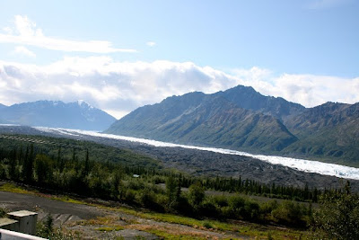
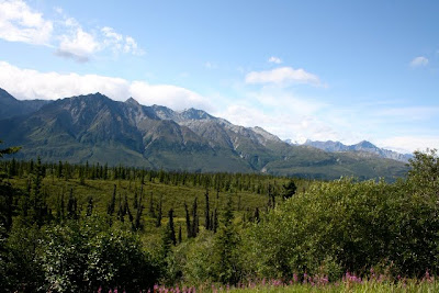
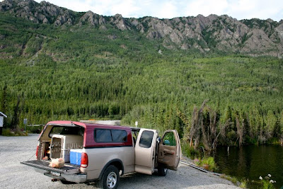
Apparently directions are not my thing. Really, I think Darren was just lucky. Eventually we made it to the Glen Highway and continued our solitary drive in the rainy darkness. The road went back and forth in classic "S" shapes. Cliff on one side, mountain on the other. I knew the view was beautiful along here as we'd driven this during the daylight on our way in. I knew there were beautiful lakes along this stretch with raging massive mountains reaching for the sky. We drove pass the small town of Sutton and drove another 15 miles. Darren pulled off the road. It was near 3:30 a.m by this time and Darren was exhausted and I knew I couldn't drive. I'd been dozing off as it was. Darren let Kenai out and took her for a walk down to the raging
river he could hear. It was a little creepy sitting in the dark truck all alone for 10 minutes. Your imagination likes to think of every possible bad thing when you're a little spooked. Here we are along a dark, desolate road, stopped, along a river that surely is swarming with fish and where there are fish, there are bear and to my left was a thick forest of trees.... It was a relief when Darren and Kenai came back to
the truck. We put the seats back, pulled light fleece blankets over us and went to sleep.

We woke up about 9 a.m. to the occasional car or truck passing by. It was Sunday and still very quiet outside. I was surprised we'd slept that long but then again we knew that we wanted the drive down to be a little more leisurely and perhaps after two weeks we were more tired than we thought we really were. We got up and I took Kenai down to the river this time. Surprisingly it was a little more civilized feeling than my mind had led me to believe a few
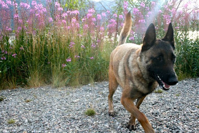
hours earlier in the darkness. There were a couple travel trailers on the other side of the river with four wheelers sitting outside their doors. Kenai ran around for a few minutes, we didn't see any bears, got back to the truck and headed out again.

From Wasilla we had the option to go to Fairbanks from there on Highway 3 but had decided to head towards Tok instead. We arrived in Tok, Alaska shortly. We knew this was the last spot for cell phone coverage for a while depending upon which way we went so we made a call to our folks, warned them of the lack of cell phone coverage, fueled up and headed for the Canadian Border. We drove along the awful stretch of neglected highway, fingers crossed that we didn't
bust another lug bolt on the wheel and then finally reached the Canadian Border building. We passed through with much more ease than on our journey up. I don't think they had any internet connection there so it wasn't so official feeling with barcode scanners and what not. The questions were much shorter and we were on our way quickly. By this time we had decided that Haines Alaska was to be our next stop. We had really started to fantasize about taking the ferry all the way down and Haines would be our last place to do this from. We also had heard that Haines Alaska was a place to see before you die...we didn't need much more convincing so we went for it.

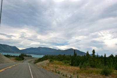
From Tok we went the same way we had come. The first "town" was Beaver Creek and then
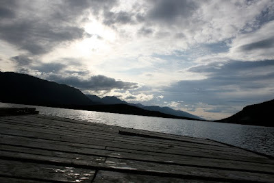
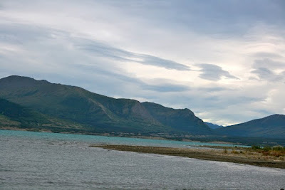
Kluane Lake and then the town of Haines Junction was to follow. We stopped somewhere to let Kenai get a drink along a little lake that had a little decrepit dock and friendly bread loving ducks. By the time we got to Haines Junction it was about 10 p.m. at least. The sun was setting. It was surprising how much faster night was coming compared to two weeks earlier. The
daylight begins to disappear rapidly. Haines Junction was a town with no fuel that I could find both when we were driving in and now, driving out. There were gas stations but all were abandoned looking. So we continued on for Haines. We stopped along the way to let Kenai out
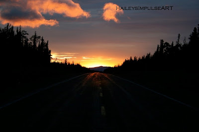
at a little lake with a tiny dock. Darkness again crept in with authority as it was still raining. As we began our trek towards Haines the fog thickened greatly. We were driving over mountains as far as we could tell. All you could see was the stretch of 20 feet of road in front of you and for the most part, all you could tell was you were alone and maybe driving through the sky. There was nothing on either side of us through much of this drive. I wondered what the view was like. I'm sure it was amazing. As the fuel gauge approached "E" and as the fog thickened I stayed more awake. Even though there were relatively no cars on this segment of road there were several porcupine encounters. Porcupines? WTF! Amidst the fog and darkness and rain were porcupines crossing the road
. Go figure. It was eerie. We thought for sure that if we were to run over a crazed road crossing porcupine that a flat tire would be a for sure thing.
One poked his head out here, another was crossing the other half of the road and the third, with some special-ops type movie style vehicle maneuvers hit our differential and we felt a solid thud under the floor boards of our truck. Luckily the larger that I envisioned porcupine missed our back tires. Phew!

We approached the U.S./Canadian Border yet again. The only way to Haines by car from Anchorage or anywhere in Alaska is by crossing back into Canada and then back into the U.S. By this time it was about two or three a.m. and the U.S. border patrol was a sight for sore sleepy eyes. We had been driving straight since Tok Alaska. The Border Patrol informed us that if one were trying to go from the U.S. to Canada at this time of night that they'd be out of luck because the Canadian Border was only open certain times but that the U.S. Border is open 24
hours, thank god. Our truck fuel gauge was literally on E at this point. We were still about an hour from Haines and the Border Patrol informed us that all the gas stations would be closed until until around 8 a.m. We didn't want to wait that long because we wanted to be on the Ferry out of Haines if possible. I knew the Ferry Station would open early, probably six so we drove for a little and found a spot to pull off the road to get a couple hours of sleep.

The town of Haines is next. Thanks for reading.

Hailey Rose


Saturday, August 8, 2009

To Watson Lake and Beyond

The drive from Fort Nelson, British Columbia to Watson Lake, Yukon Terriotory was about 6 hours which would be like driving from Salt Lake City, Utah to Las Vegas, Nevada but way more boring. The scenery was repetitive. Nothing much had changed since Dawson Creek. Twelve hours of the same scenery gets quite boring. We did however get to see some great wildlife. There were some wild sheep just hanging out on the road, black bears and some beautiful herds of buffalo. That spiced things up quite a bit. The construction along the way slowed us down quite a bit too. In certain places we waited for at least 30 minutes for the pilot truck to come back to lead us through the miles of construction. People were out of their cars/trucks/RV's hanging out, enjoying the sunshine. Others were going along the tree line picking wild strawberries. By the time I decided to pick some wild strawberries, the line started to move so I jumped back in the truck with my four little wild strawberries. It was a tease to our taste buds.

To help pass time I started reading aloud to Darren while he drove. This helped keep both of us awake and being the book was really good helped a lot too. I read an old Matt Helm book to him. The Menacers, by Donald Hamilton was what it was called and it was from the 1960's era. This book is one of a series and all about a U.S. secret agent. Very realistic, very fascinating. I gave the characters voices and expressions. I paused when there needed to be a pause, I gave as much life to the words as I could to make it as interesting for him and for me as possible. This made it a lot of fun. I tried to read facts about the towns we were driving past such as population statistics, historical events, dates, etc. But he found that kind of information very boring.
Speaking of statistics, here are some that I found very interesting about Watson Lake, Yukon Territory courtesy of the Milepost Magazine (aka Bible to Driving the Alaska Highway):

Watson Lake:

Population: 1,563
Elevation: 2,265 feet
Climate: Average Temperature in January is -16 F (-27 Centigrade), in July 59 F (15 C)
In January 1947 the record LOW was -70 F (-59 C)!! NEGATIVE 70! I get cold just thinking about it.
In June 1950 the record high was 93 degrees F (34 C).
Annual Snow fall is 90.6 inches
Average date of last spring frost is June 2
Average date of first fall frost is Sept. 14

Watson Lake is also the home of the famous Sign Forest where there are more than 60,000 signs. We didn't stop. Darren said it was silly... kind of like going to see the largest ball of yarn. I disagreed. haha We refueled in Watson Lake for some ridiculous amount of money and continued on. Our goal was to get to Port Alcan, also known as the border back into the U.S.

We passed through a beautiful little town called Teslin. The bridge was one of the prettiest bridges to cross so I took some pictures.

After Teslin, as the scenery began to get more exciting we were headed for Whitehorse. I still hadn't had any cell phone service and I hadn't spoken to my parents in over a day. I was hoping they weren't beginning to think we'd gotten eaten by a bear or stranded, or both so I was anxious to let them know I was okay. The population in Whitehorse is over 24,000 so I figured I could call my parents from there. Whitehorse was another 5 hours from Watson Lake.
Whitehorse was an interesting town. You had to actually drive down a couple miles off of the Alaska Highway to reach the town. It seemed to be quite a large city with quite a bit of traffic. But.... no cell phone service. So I used a pay phone to make my call. $8.50 to make one long distance call from a pay phone for a couple minutes. Ouch! Had I known that I would have service almost instantly once across the U.S. border, I would have waited. Live and learn. We fueled again in Whitehorse and charged forth for Port Alcan.
Port Alcan was about another 6.5 hours drive, but there's no town at Port Alcan, just a border crossing. Tok, the first town once back in the U.S. was another 1.5 hours after that.
The section of road past the Canada border station but before the U.S. border station was the worst section of road ever. It seemed like neither country wanted to claim that section of road and therefore did nothing to it. The road was really bumpy. Not pothole bumpy really but it was like the land under the asphalt had rolled, heaved, thawed and defrosted and this just demolished the once smooth asphalt. There were no lines to follow, no signs except for the one that said 100 km/hr but there was no way you could travel at 100 km/hr. By this time it was dark outside and with the road in such awful shape, 60 km/hr was about as fast as one could go on that messed up road.
When rolled up at about 2 a.m. to Port Alcan. We were stopped at the red light they had out front and waited. The lights came on in the station and you could see a couple of border patrol agents moving around. I wondered if they had been sleeping and I hoped they wouldn't take their lack of sleep out on us. After a few minutes our light turned green and we slowly pulled up to the agent. As we rolled up we could hear something rolling around in our front hubcap. The agent heard it too and commented, "Sounds like you got a rock in there." We handed him our passports, he asked some of the same questions as the Canadian agent had asked. He informed us that the gas stations in Tok were closed until morning. He went inside to scan our passports and while he was doing that, Darren jumped out to pop the hubcap off to see what the noise was all about. Apparently we had cracked and broken one of the lug bolts. Thank goodness the wheels had five so we still had another four to hold the wheel on. The agent came back out and gave us our passports back and we continued on.

By this time we were really tired. Darren had been driving for the past 4 or so hours and I was way too tired to take over so we drove for about 20 miles and found a quiet spot to pull off and sleep. We were finally back in the United States. Not to knock Canada really, but it was just nice to see speed limit signs that we fully understood and it was amazing how much nicer the pavement was and how bright the lines were. It just felt good.

We let Kenai out to run around, fed her and then snuggled up in our blankets in the truck and fell asleep. The next day was Sunday and we had to be to Anchorage that Sunday night to pick up the family. So far we were making good time.

Thanks for reading as always.

Hailey Rose
P.S. Don't forget to come visit my shop. www.impulseART.etsy.com


Tuesday, August 4, 2009

Where has Hailey been?

Dear Friends,

I know it's been several weeks...ok, like a month since I blogged but I have a really good reason.

Early July my darling fiance and I left town to go on a great expedition, a great adventure for 3 weeks. We had been planning this trip since last fall. Our list of things to buy so to be ready began months ago.

Cool Backpacks ......... check!
First Aid Kits for each bag ......... check!
-40 Sleeping bags (a bit excessive for summer but who knows where we may go) ........ check!
Magnesium Stick for making those fires ............. check!
Emergency Blankets ..... check!
Flashlights ...... check!
Dried Food .... check!
90 seconds to boil water expensive thing that's really cool ......... check!
Water purifier ....... check!

....well, you get the idea.

Fortunately we didn't need to use much of any of this stuff... but we were ready for just about anything.

Okay, are you dying to know where we went now? We started here in beautiful Utah and drove to Homer Alaska. 62 hours of nearly straight driving, a few "space food" meals .... a few bathroom breaks, a couple little naps, way too many sunflower seeds and potato chips, and lots of fantastic scenery later.... we were in Homer Alaska. The journey had only begun.

Over the next few days, I will be write a blog daily about our adventures, experiences along with pictures from our adventure. I hope you enjoy this and my future blogs.

Thanks for reading...

hailey rose

... check my store, I have a couple photos listed in my shop from my trip!


Powered By Blogger